Summary
A. Introduction
B. Geography, a) Where did we go?
C. Geography, b) Deserts, Mountains, Seas/Lakes, and Canals
D. The Silk Road
E. Vignettes
1. Border crossings, especially into Turkmenistan
2. The Headless Goat Game, Kok Boru
3. Turkmenistan is Really Bizarre
4. Iskanderkul Lake – high in the mountains
5. The Darvaza Gas Crater
6. An unusual dinner, of shashlik
7. The Navruz Palace
8. A last minute soccer game decision
9. Issyk-Kul Lake
10. The Fifty Fortresses (The Khorezm fortresses, known as Elliq-Qala)
11. Toilets I must describe
12. A very old chachvan – my big “mask” purchase
13. The Borat echo
F. Attachments
Attachment #1: Geography, c) Cities to be noted
Attachment #2: History, Ancient and Current – a modest sampling
Attachment #3: Religion, with Islam Predominating
Attachment #4: Food and drink
Attachment #5: Language
Attachment #6: Itinerary and Transportation, Summary
A. Introduction
Rarely have I had such a journey that has so left me with the need to, after the trip, reflect, research, and explore more about what I encountered. It exposed me to geography, history, and cultures with which I was not familiar.
One result is that I’ve spent some time adding important historical entries to my “Key Dates in World History” document. (The updated version can be found at: https://powellponderings.com/attachment-1-key-dates-in-world-history-the-big-bang-to-4-bc/.)
While each “Stan” deserves attention, I’ll try and talk at first about the geography and then comment on what ties this together – the Silk Road. In my attachments I touch on history, religion, food and drink, and language.
The shadow of Russia hangs over all of the Stans, so I have also tried to capture that theme. I do remain undeterred from my February 29, 2022 conclusion that Russia remains “a vile, evil, and disruptive state” (See: https://powellponderings.com/russia-a-vile-evil-and-disruptive-state-attachments-to-part-2/).
I’ll use “I” a lot, but I travelled with a group of 15 others (and quite an experienced group it was, with a wide range of backgrounds, which made it further interesting), all on an organized trip conducted by Adventures Abroad. This is an excellent tour company and we were well led by the overall tour leader Jonathan Hodgson, who was charming and very experienced.
The more important fact is that I travelled with my oldest son, Brendan. (This trip did not attract Penny – the first time she has ever declined to join me in my travel choices!) Brendan and I got on very, very well, which was a huge bonus (for both of us) in choosing this journey. As well he supported, literally, my “game” knee challenges, usually due to rough terrain. A month before we left we also attended a special evening eating food from Kazakhstan, which gave us a certain familiarity with what we were going to eat.

Interestingly, Brendan in his days after graduating from Queens and figuring out what he wanted to do with his life, worked as a tour leader for Adventures Abroad, and wandered the world for seven years doing so. His brother, Dylan, in an extraordinary coincidence, had to make a business trip to Pakistan at the same time as we were negotiating the Stans. (He’s VP of MaryBrown International, and develops the international franchises.) He sent us a photo, as a joke, of him surrounded by security guards, complete with sub-machine guns!
While there are obvious commonalities among the Stans, the distinctions are many – geographic, cultural and historical. I’ll briefly cover some of that, but then just describe some wonderful and colourful anecdotes I’ve selected from the many that occurred during my journey.
B. Geography, 1) Where did we go?
My travels over the years have circled this Central Asia area but never entered it. So let me highlight where we were in relation to the neighbourhood. Look at the following map. First of all, the obvious: they are all landlocked counties (with the exception of the Caspian Sea). It shows Russia floating on the top of the largest and northernmost Stan, Kazakhstan. To the east China borders three Stan’s – Kazakhstan and the two smallest Stan’s – Kyrgyzstan and Tajikistan.
Across the south, three countries touch on the Stans – Pakistan and Afghanistan (they border Tajikistan, a bit of Uzbekistan, and a lot of Turkmenistan, and the third country to the SW being Iran. (We were within a few kilometres of Iran during our 5th travel day.)

By the way, the suffix “stan” means “place”. It comes from the Persian word istan which means “land” or “place of”; it’s used to indicate place where people of a particular culture or group live.
C. Geography, 2) Deserts, Mountains, Seas/Lakes, and Canals
Rugged and inhospitable terrain define the Stans. No wonder they were such a challenge to transit in the Silk Road days.
The deserts are enormous in three of the five Stans. The exceptions being Tajikistan and Kyrgyzstan, which are mostly mountainous. In Uzbekistan the Kyzyl Kum desert lies to the northeast. In Turkmenistan nearly 80% of the country is taken up by the Karakum (Black Sand) desert, the largest in the Commonwealth of Independent States (which is made up of Russia and the Stans plus others). 90% of Kazakhstan is made up of steppe, the sand massives of the Karakum and the vast desert of Kyzylkum (which means “red sand”), a huge and desolate place.
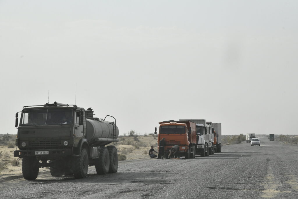
What does this mean for travellers? Desert conditions mean long drives over roads that are quite frankly atrocious. There are almost no facilities along the way, so you’ve got to be independent. We passed many a tire that had blown or disintegrated. We also passed quite a few vehicles (mostly trucks) that were experiencing mechanical difficulties. Men (always men) were labouring on some part of the vehicle to encourage it to produce a few more miles.
The mountains are many and very dramatic. The Tien-Shan and Pamir-Alai mountain ranges dominate in both Tajikistan and Kyrgyzstan while the latter had other ranges. As a result 94% of both counties is mountainous. (Kyrgyzstan’s average elevation is 2,750 metres; the highest point is Peak Pobedy at 7,439 m, with another being Lenin at 7,134 m.)
And the seas: To the west is the enormous Caspian Sea which is on the western edge of the Kazakhstan and Turkmenistan borders. This sea straddles Europe and Asia and contains 143,000 square miles of water area. (Our own Lake Superior ain’t so superior and is less than a quarter it’s size.)
Then there is the Aral Sea (it’s really a lake – formerly the fourth-largest one in the world). It was water but began shrinking in the 1960s and has now shrunk to a mixture of toxic chemicals from industrial projects, runoff of pesticides and fertilizers, and toxic chemicals from weapons testing. Thank you Russia. It has now largely dried up over the past 15 years. A current plan is in place with all the Stans cooperating to rehabilitate the area. This has been tried in the past.
Two lakes are worth noting. The first is the enormous Issyk Kul Lake. Surrounded by the Tian Shan and Pamir-Alai mountain systems which occupy two-thirds of the Kyrgyzstan area.
The second is Iskanderkul Lake. Both these lakes figure in my vignettes later.
Regarding canals, the second-largest irrigation canal in the world, the Karakum Canal, crosses the Karakum desert which brings water from the Amu Darya River to the southern regions of the desert. It is in Turkmenistan and runs through the capital city, Ashgabat. The canal is also a major factor leading to the Aral Sea disaster I just referred to.
For Geography 3) Cities, see Attachment #1.
D. The Silk Road
The well known travel writer Colin Thubron said it well: “To follow the Silk Road is to follow a ghost. It flows through the heart of Asia, but it has officially vanished, leaving behind it the pattern of its restlessness.”
One can’t talk about the “Five Stans” without reference to the Silk Road. Scorching deserts, high mountain passes and caravan towns define the route (or as it was then, routes) transporting silk and various other goods from western China to eastern Europe from as early as the second century BC until the mid 15th century when the Ottoman Empire closed off trade with the West. Nearly 6,500 kilometres long, it connected the Eastern and Western worlds.
And it connected it through Central Asia. Caravans with camels or other pack animals crossed these diverse and rugged “Stans”. Our own journey took us through towns and cities that grew because of their geography along one of the Silk Road routes: Bukhara, Khiva, Samarkand, and Tashkent (the capital) in Uzbekistan; Ashgabat (the capital) and Mary (Merv in ancient time) in Turkmenistan; Almaty in Kazakhstan; Bishkek the capital of Kyrgyzstan; and ancient Penjikent in Tajikistan, along with its capital, Dushanbe.
The “silk” refers to the trade of silk textiles, invented around 2700 BC in China (which monopolized production until the secrets spread) and sold to an adoring market in Europe and beyond. (Its production technique was a fiercely guarded secret within China for some 3,000 years, with imperial decrees sentencing to death anyone who revealed to a foreigner the process of its production.)
Other trade products came along – tea, perfume, spices, porcelain, paper, gunpowder, jade and precious stones – an amazing collection of sought-after goods that warranted transport over great distances and difficult, dangerous terrain. Commodities returned back along the route too, such as glassware, wools, manufactured goods, and even horses. Few merchants travelled the full distance, as middlemen would take sections of it. Local knowledge was critical, especially dealing with, and protection from, those who lived along the way.
Other things passed along this route as well: religion, languages, and cultures developed and influenced one another (it helped spread Buddhism, Christianity, Islam, Zoroastrianism and Hinduism); technologies and innovations (horses introduced to China contributed to the might of the Mongol Empire; gunpowder from China changed the nature of war in Europe); and diseases (some research suggests that the Black Death, which devastated Europe in the late 1340s, likely spread from Asia along the Silk Road).
Eventually ships carrying far larger amounts of goods, created greater economic impact, plus carried different goods than the caravans. While traders on a maritime route faced different perils like weather and piracy, they were not affected as much by political instability.
The famous Catalan Atlas of 1375 includes the first known depiction of the Silk Road: an image of a caravan of merchants and camels (which is also thought to include the man often connected with the route, Marco Polo and his family, around 1274). One of Polo’s diary entries was intriguing: “I did not write half of what I saw, for I knew I would not have been believed.”
Each country we passed through seemed to carry that old trading route deep in its soul.

E. Vignettes
Instead of a day by day diary account of the delights and challenges of exploring the five Central Asian “Stans”, I have chosen a number of memorable vignettes and experiences to tell the story another way.
1. Border crossings, especially into Turkmenistan
We had borders of five Stans to navigate, and one of them twice. While they all had their idiosyncrasies, there was one that we knew would be a challenge – the Uzbekistan into Turkmenistan crossing.
When we reached the border, the ritual began, and lasted for over four hours. First we had to officially leave Uzbekistan, which we did. Then at the first Turkmenistan contact, we showed our (pre-organized) invitation letter to visit Turkmenistan. This we had arranged months ago. We walked through “no mans’s land” dragging our bags and then took a one kilometre bus ride. Soldiers with all manner of guns, watched us.
I had been warned that no photographs should be taken. This was a serious order. I got a few. This photo was taken (without looking), while crossing by foot over “no-man’s-land”.


Once we reached the Turkmenistan side of the border, we were then submitted to a COVID PCR test (and paid $30 crisp US dollars for it). Probes were inserted up our noses by “a doctor”. (He did have a white jacket on.) The results took about an hour to come back; no COVID was detected.
We were now in a line, but it wasn’t. We were a bunch of supplicants inching forward to the two customs officers. Elbowing and shouldering techniques were displayed. The visas were finally inspected and we then coughed up more crisp US dollars, 73 of them.
Bags were then scanned, and some were inspected. We all showed our passports at least six times in the crossing; each uniformed officer really did look at them, or pretended to.
This all reminded me of the Woodie Guthrie song, the Alice’s Restaurant Massacree. Woody is in the draft centre being signed up for the US draft. I’ll let him talk now; he says: “Proceeded on down the hall gettin more injections, inspections, detections, neglections and all kinds of stuff that they was doin’ to meet the thing there, and I was there for two hours, three hours, four hours, I was there for a long time going through all kinds of mean, nasty, ugly things and I was just having a tough time there, and they was inspecting, injecting every single part of me, and they was leaving no part untouched.”
Yup, it was sort of like that.
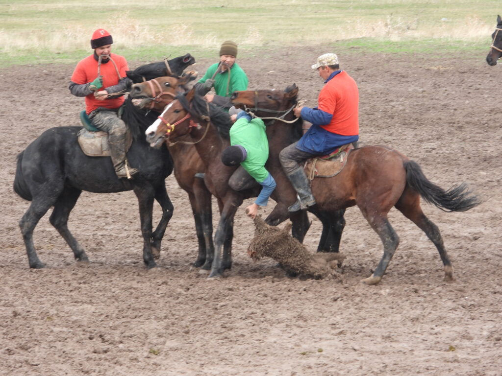
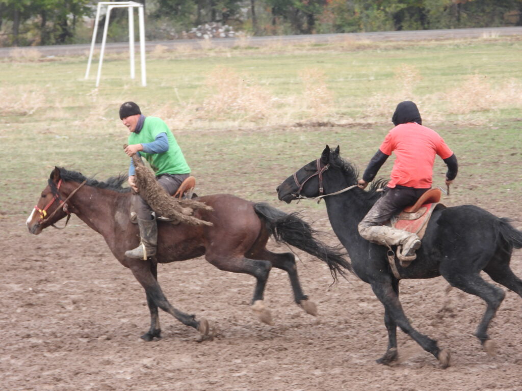
2. The Headless Goat Game, Kok Boru
OK, you won’t believe this one. Near the end of our journey we were taken to a large field that looked like a soccer pitch, with lines marking the exterior and, as it turned out, two large circular mounds that served as goals. We were about to see a most unusual game. Called Kok Boru, a traditional Kyrgyzstan game was to be played in front of us. Two teams of four riders on horses faced each other. In the centre of the field a fresh dead headless goat was lying on the ground. I repeat, a dead headless goat.
The rules were simple. The objective was to grab the goat carcass and throw it in the other teams goal – the elevated circular mounds at both ends of the field. Each team had the same objective, thus a vigorous clash occurred once the signal was made for the game to start. You could tell it was difficult, requiring considerable strength and horsemanship. The goat is heavy (~75 pounds) and hard to grasp (no head). Each team is very aggressive in attacking anyone with the goat or protecting your own player with the goat.
Back and forth the teams went. The goat would often be yanked from an opposing player’s grip, fall to the muddy pitch (it had recently rained), and often at a full gallop be grabbed by an opposing player and manipulated under a leg whereupon a mad sprint would ensue towards a mound.
The game goes back thousands of years. When the people of Kyrgyzstan were nomadic, wolves would attack and eat their livestock. Since their livestock was also their livelihood, this was a problem. To ensure survival, they would kill wolves they saw. Eventually, they developed a use for the wolf carcass: Kok Boru (Blue Wolf). What might have started as a game played by shepherds to pass the time, has become a cultural symbol of both Kyrgyzstan and Kazakhstan. In the present-day world, the wolf carcass has been replaced with a goat carcass.
The final score was 2 to 1, and the winners got to keep the goat, which apparently will be used for the evening meal in their village.
3. Turkmenistan is Really Bizarre
OK, so what is this quirky white car affectation the president of Turkmenistan had? I’ll explain in a sec. Since its severance from the Soviet Union in 1991, the country has been ruled by two “presidents” (read “dictators”). Plus the second dictator’s son. Remember, the country had more or less been closed to the outside world. These men have put in place some of the most bizarre and self-centred edicts imaginable. Remember also as you read, that the country has the fifth largest reserves of natural gas in the world. That’s quite a bit of cash flow.
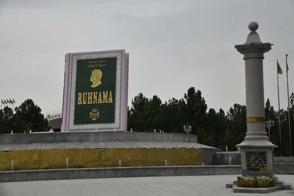
The first president styled himself “Türkmenbaşy” or “the father of all Turkmen”. He wrote an autobiography called Ruhnama, containing his thoughts on Turkmen identity, history, and destiny. He then made the book mandatory curriculum in the schools. New governmental employees were tested on the book at job interviews and an exam on its teachings was a part of the driving test. He even had a copy of his book launched into space to orbit the Earth, and of course made a public statue of it, as you can see in this photo.
He renamed the days and months after himself and his family members. He banned opera, ballet, and circuses for being “insufficiently Turkmen”. He closed down all rural libraries and hospitals outside of the capital city Ashgabat, in a country where at that time more than half the population lived in rural areas, once stating that, “If people are ill, they can come to Ashgabat.” He commissioned a giant, rotating gold statue of himself. The boulevards are broad, and eerily empty of traffic, and spotless. Women with brooms sweep like there is no tomorrow.
After his death in 2006 the next president, Gurbanguly Berdimuhamedow, (I’ll call him GB), brought in some other delights. And this gets me back to the car colour issue. GB’s first edict was that all cars in the capital must be white. He continued with the buildings too, so there is a lot of white marble. Lavish monuments are prolific. There is a huge monstrosity of a building that’s called the Wedding Palace as it was built only for weddings. He has some unusual firsts. The country has the highest flag pole in the world (complete with a jet engine to push the flag out so it’s flutter can be appreciated). Ashgabat has the most fountain pools in a public place. GB wanted, and got, the world’s largest and only indoor, i.e. enclosed, Ferris wheel. Here is a photo of it.

We visited a horse stable, where we posed with their revered Akhal-Teke horses so loved by Türkmenbaşy. They have a reputation for speed and endurance, intelligence, thin manes and a distinctive metallic sheen. One of the city’s monuments commemorates Turkmenistan’s horses.
We exited the city (and headed to Mary which is located near the famous Silk Road city of Merv) flying out of their new airport which was built in 2016. (I expected the flight to be one where everyone cheers when you land – remember that in the old days; they didn’t, although the plane was a nearly 30 year old Boeing 737-700!) The airport had an unusual terminal design – the shape of a falcon. It has the capacity to serve 14 million passengers per year at a rate of 1,600 passengers per hour. (Total country population amounts to around five million.)
4. Iskanderkul Lake – high in the mountains
One day from Penjikent, Tajikistan, we drove to this lake, high in the snow-capped Gissar Range of the Fann Mountains. It is also known as Lake Alexander, after Alexander the Great. This was a detour on our way to Dushanbe, the country’s capital.
Getting to this lake required a group of 4×4 vehicles heading deep into the mountains, initially following the very long (nearly 900 kms) Zarafshon River. Besides the Fann Mountains, the south and east part of Tajikistan is dominated by the Tien-Shan and Pamir-Alai mountain ranges. Stunning mountain scenes were a constant.
Winding around hairpin turns, we dodged cows, goats and donkeys roaming free on the highway, along with sharp turns, honking and certainly my foot braking instinctively. Highway road repairs were taking place. I have a photo of our driver driving UNDER the enormous fully operating arm of a front-end loader, complete with a load of gravel in his bucket! Seriously.
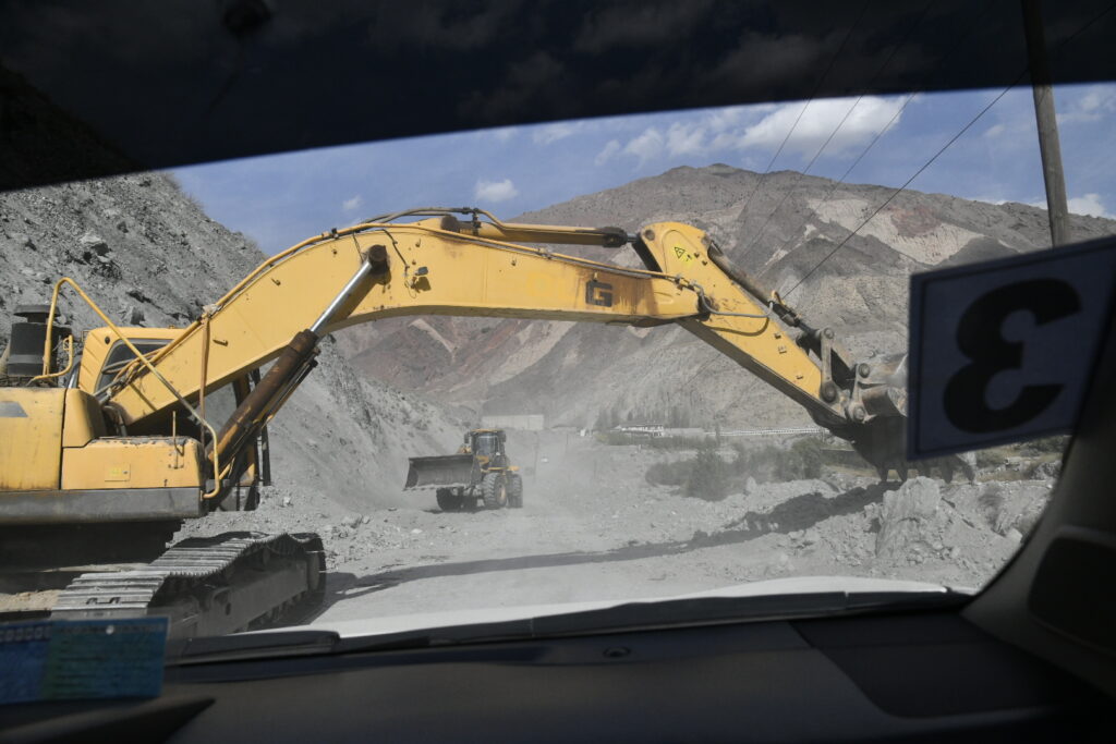
The driver that day was typical. While we were never really in a hurry, you wouldn’t know it by his habits. While sombre looking, his aggression was palpable: honking was essential; riding tight on the ass of the car in front, standard. He would often use both his cell phone AND a walkie talkie.
After driving through the Varzob Pass, we finally reached this lovely glacial-fed lake at an altitude of around 2200 metres. The lake was cool, running between 4 and 10 degrees Celsius. Legend has it that the local inhabitants resisted Alexander’s rule, and in fury, the king ordered the river to be diverted to annihilate them. He did that sort of thing, so it may be true.
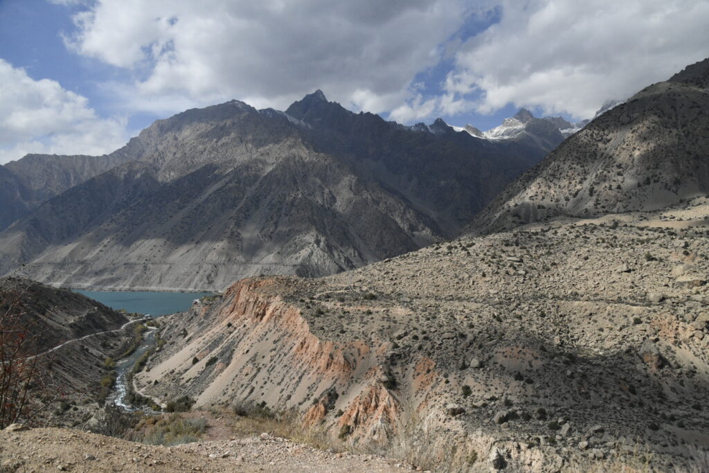
Settling in by the lake we consumed the lunches we had bought earlier in our visit to a terrific market place when we exited Penjikent. Surrounding us were the abandoned buildings of an old run-down Russian holiday camp. It was a strange contrast to the natural breathtaking surroundings: high mountain peaks, soft clouds with the sun peaking out intermittently, and this stunning blue lake. A large tract of land including the lake and surrounding mountains has been designated a nature reserve where significant numbers of various bird species are supported.
Amusingly, on the journey we passed quite a number of large (I mean large) pictures of the current president of Tajikistan, Emomali Rahmon. There is definitely a cult of personality going on here (a Stan theme?). He heads an authoritarian regime and has won five presidential elections since 1994. Important government positions are occupied by his family members. His 36-year-old son is the chairman of the country’s parliament and the mayor of its capital city, Dushanbe. Tajikistan’s parliament in 2015 gave Rahmon the lifetime title “Founder Of Peace and National Unity, Leader of the Nation”.
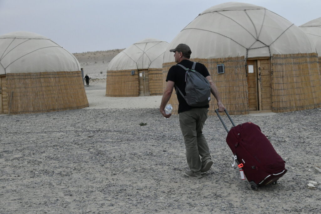
5. The Darvaza Gas Crater
The Karakum desert is home to a huge natural gas crater, about 260 kms from Ashgabat, the capital of Turkmenistan. To reach this crater a very long drive in our 4×4 vehicles took place over a “highway” that has not been maintained for years. Asphalt had once graced the surface, but it has mostly disintegrated. It wasn’t just rough, the vehicles encountered huge holes that just needed to be avoided. Speed was not possible (oh, the drivers tried!) so jerking and swerving was the hour-by-hour experience (nearly nine hours in and out).
A magnificent sunset graced us as we arrived and checked into our yurt. The site has become a tourist attraction, so a development has sprung up near the crater complete with a number of yurts to bed down in plus restaurant facilities.
The yurt, by the way, is a fairly large round tent covered and insulated with skins or felt, with a door but no windows. Ours had two beds and a place to hold your clothes. Traditionally they were used as a dwelling by nomadic groups, and thus are portable and can be assembled and taken down quickly. Washroom facilities are somewhere else.
After dinner we walked over in the dark about half a kilometre to check out this strange phenomena. Hundreds of natural gas fires illuminate the floor of a huge crater, sized about 30 metres deep from the rim of the crater and about 70 metres across. It was surreal and sort of attractive, like Christmas time when all the lights get hung up.
It’s also called the “Door to Hell” or the “Gates of Hell” by locals – for a reason. Dante couldn’t have done a better job at creating an entrance to where I probably will end up when I finally kick the bucket.
In an interview with National Geographic, a scientist who was the first person to set foot at the bottom of the crater said: “I describe it as a coliseum of fire – just everywhere you look it’s thousands of these small fires. The sound was like that of a jet engine, this roaring, high-pressure, gas-burning sound. And there was no smoke. It burns very cleanly, so there’s nothing to obscure your view. You can just see every little lick of flame.”
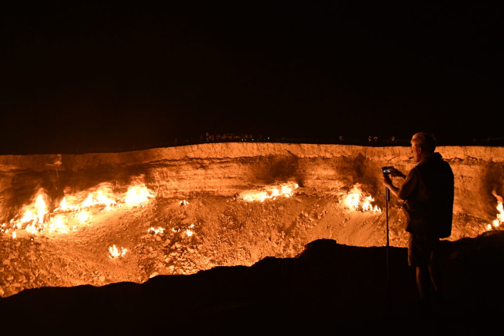
There are confusing tales regarding the origins of this crater. One assertion is that the site was drilled by Soviet engineers in 1971 as an oil field but it collapsed within days, forming the crater, with the engineers choosing to flare the crater to prevent the emission of poisonous gases. Some local geologists have claimed that the crater collapse happened in the 1960s and that it was set on fire only in the 1980s because of these gases. Strangely, records are either absent from the archives, classified, or inaccessible. My own take is that the Russians tried to drill and really mucked it up, and just let it burn.
In the morning it took another four hours in our 4-wheel drive cars dodging pot holes and photographing camels to reach Ashgabat.
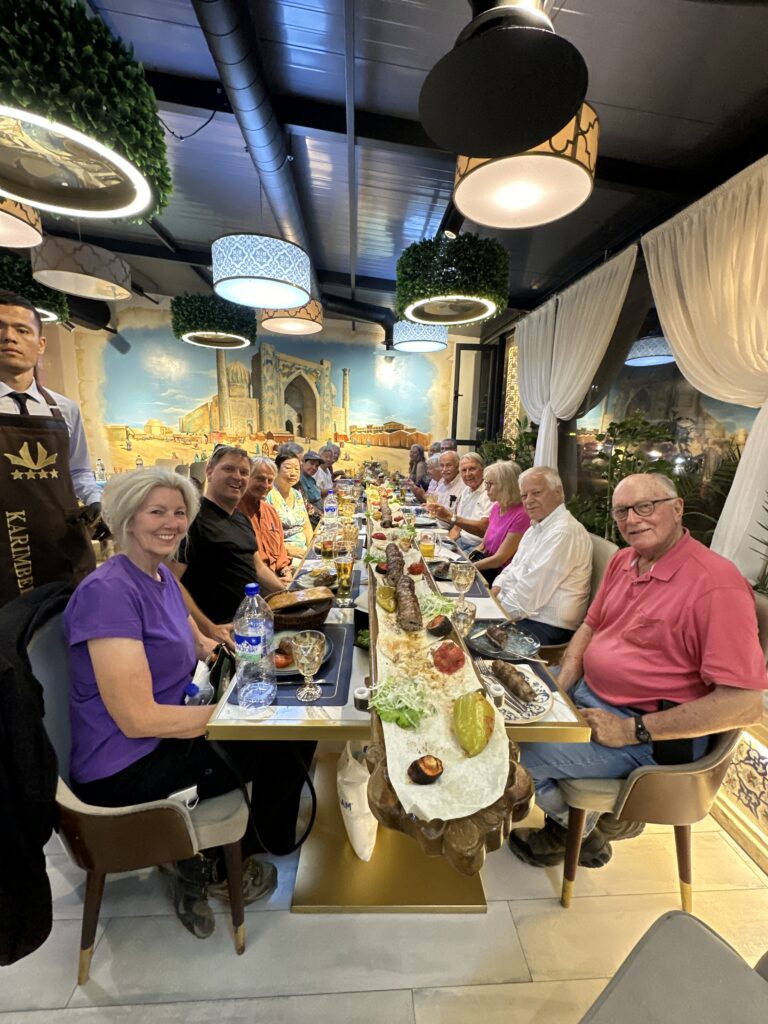
6. An unusual dinner, of shashlik
On our first night in Samarkand we were entertained by the presentation of our dinner. It started off in a regular fashion. We were all seated at one long table. I ordered a beer and nibbled at some bread. Then out from the kitchen came four waiters carrying a very long board (at least 14 or 15 feet long) upon which was placed an also very long continuous chunk of ground meat, sort of sausage shaped, all on one long skewer. It was called shashlik.
The waiters and waitress were singing, laughing, clapping and dancing as it was brought over our heads and placed in front of us on the table. We also got into the singing and clapping mood. On the table were placed lit sparklers.
The meat was lamb and quite flavourful and juicy with lots of onions. It was kind of like shish kebab. (Apparently the word shashlik entered English from the Russian shashlyk, of Turkic origin. In Turkic languages, the word shish means skewer, and shishlik is literally translated as “skewerable”.)
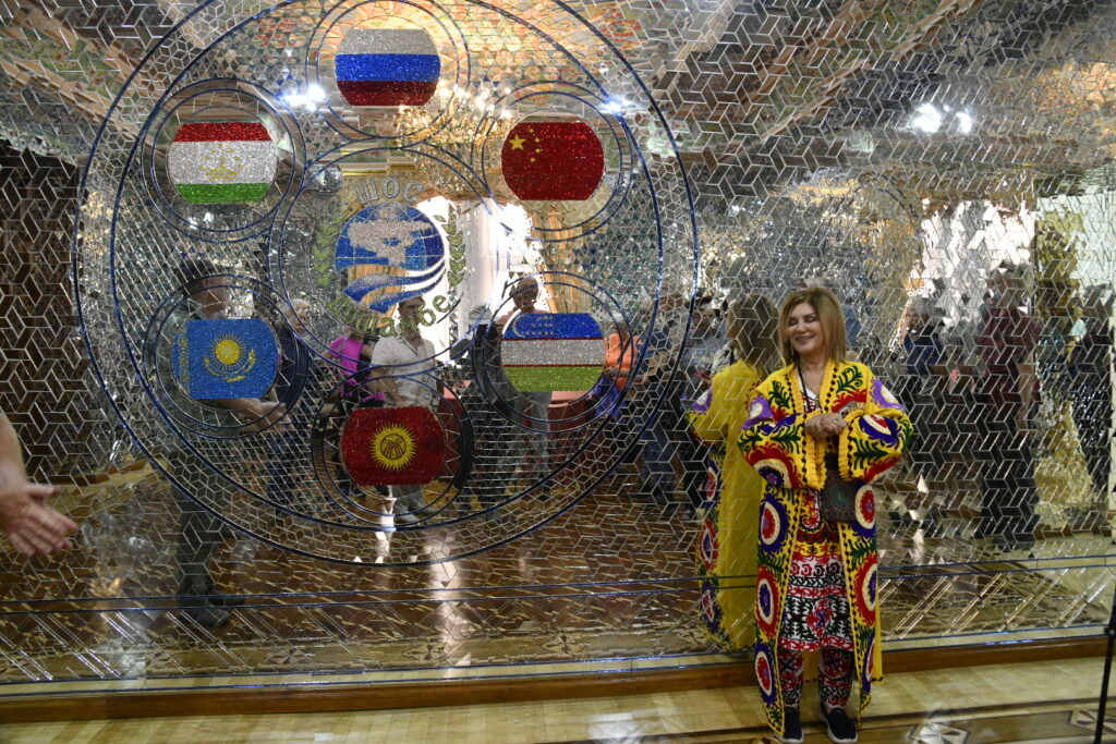
7. The Navruz Palace
In Dushambe, the capital of Tajikistan, we visited a monstrously garish “palace”, which essentially is a high level meeting place. It was very expensive to construct, apparently costing $60 million, so it is quite likely the government paid for it. It’s almost new, built ten years ago and designed for formal functions. It was built, we were told, because the “local business people wanted it”, an explanation that makes no sense at all. This may be a catch phrase for redirecting a government’s need on to a neutral, blameless party.
Nearly 30,000 square metres of rooms are spread over four floors and everything about it is over-the-top. Wood carvings, chandeliers, fine plaster decor, unusual ornate chairs, enormous tables, inlaid floors were all very expensively done. A strange lady in a colourful traditional Tajik outfit toured us around and talked like an automaton. She emphasized the size and quality of everything, particularly the two rooms used for large multi-people meetings and conferences. But as far as I can tell, not many happen.

There is a smaller room full of mirrors where they have flags of the countries of the Shanghai Cooperation Organization that was established by China and Russia in 2001. This is an Eurasian political, economic, international security and defence organization and it is the world’s largest regional organization in terms of geographic scope and population (it covers 24% of the world and 42% of its population). This is the kind of group that meets in such a “palace”. A light bulb came on in my head when I realized that this may explain my original disbelief about who really wants and uses this facility.
8. A last minute soccer game decision
A soccer World Cup qualification match was being played between North Korea and the Kyrgyz Republic the night we arrived in Bishkek, Kyrgyzstan. Upon returning from dinner, five of us decided on the spur of the moment that we would see if we could buy tickets to see the match.
It was half time when we navigated our way up the concrete bleachers into our seats. We were surrounded by Kyrgyz fans, so we lustily cheered on the home team – which hung on to the one goal that they scored in the first half. North Korea put on quite a push in the last ten minutes and almost scored a couple of times.
The fans were wild. They realized we were strangers to their stadium and they were pleased when we got into the excitement. They even gave us some cheap rain gear when it sprinkled for a few minutes.
The scoreboard said the attendance this night was 9,840; almost all of whom, including us, left delighted with the Kyrgyz Republic victory.

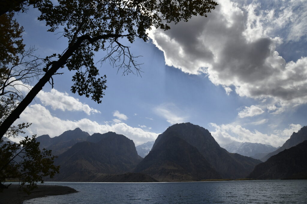
9. Issyk-Kul Lake
This lake is described as the “beating heart” of the Tien Shan mountains. The days we visited the lake and area were beautiful fall days. The mountain ranges, most of which exceeded 5,000 metres in height, were clearly defined. The combination of deep blue skies with billowy clouds sitting above blue-grey mountains topped with snow, and the cool blue of the lake was quite special.
The lake itself is enormous, being the second largest mountain lake in the world – 178 km by 64 km in size, plus it’s 1600 metres above sea level. It’s the tenth largest lake in the world by volume and the second largest saline lake, after the Caspian Sea. It never freezes, hence its name, which means “warm lake” in the Kyrgyz language. It’s fascinating to realize that there are significant ruins under the waters from two periods (a 2,500 year old Saka settlement and an Armenian monastery from the 14th century) and they are now being excavated.
We climbed aboard a good sized vessel and motored out quite some distance, whereupon beer, wine and vodka appeared, to enhance the view. The ravenous sea gulls gobbled up the pretzels we tossed.
The drive there highlighted the reality that mountains cover more than 80% of the country, Kyrgyzstan, and why it’s nicknamed the “Switzerland of Central Asia”.
Prior to our boat ride we followed a fascinating walk among 1900 to 2800 year-old petroglyphs from the time of the Saka-Usun peoples, along with wandering sheep who also seemed to be inspecting the stones. Images such as hunters pursuing wolves and deer were carved into the stones.
10. The Fifty Fortresses (The Khorezm fortresses, known as Elliq-Qala)
We were in the middle of the very barren Karalpak desert, between Nukus and Khiva when the first fortress appeared almost as a mirage. These date back more than 2,000 years although the area has been occupied since the Old Stone Age (i.e. as far back as 11,000 BC).
We scrambled around a couple of them – Toprak Qala from the 1st or 2cd century AD being the first. They exist in a region that is sometimes called the 6th Stan, Karakalpakstan, which while part of Uzbekistan, is autonomous. They are now UNESCO “protected”, although that doesn’t mean much when there is no structure or people to do any protecting.
We saw what essentially were mud bricks forming a structure rising a few hundred feet out of the desert (the view was great from the top). No railings, no directions, no nothing except our local guide explaining to us that this was part of a system of ancient desert castles or fortresses.
The ruins show the complex urban layout, including temples, houses and more. At its height, it accommodated a population of 2,500 people. Toprak Qala was both a fortress and a royal residence, and archeologists have identified a throne room, fire temple, and an armoury inside the citadel. An ancient system of canals brought water to the city from a now dry branch of the Amu Darya River.
These fortresses existed in a rough time, and were subject to multiple attacks. Power struggles in Central Asia, particularly in the wake of Alexander the Great’s death in 323 BC, were constant.
Camels wandered around at various times during our desert excursions, as you can see.

11. Toilets I must describe
This had to be in my notes. A trip travelling over 10,000 miles (locally) and this many methods of travel and with varied foods and drink that challenged the gut produced its full share of toilet challenges.
There were Western style toilets in the hotels, and some restaurants. Then there were the “crouch down and aim backwards” squat toilet style that Western tourists talk about. Everyone on our trip was advised to carry our own toilet paper as there usually was none to be found. On the rare occasion that there was some, it had a unique sandpaper, grade “rough”, quality to it.
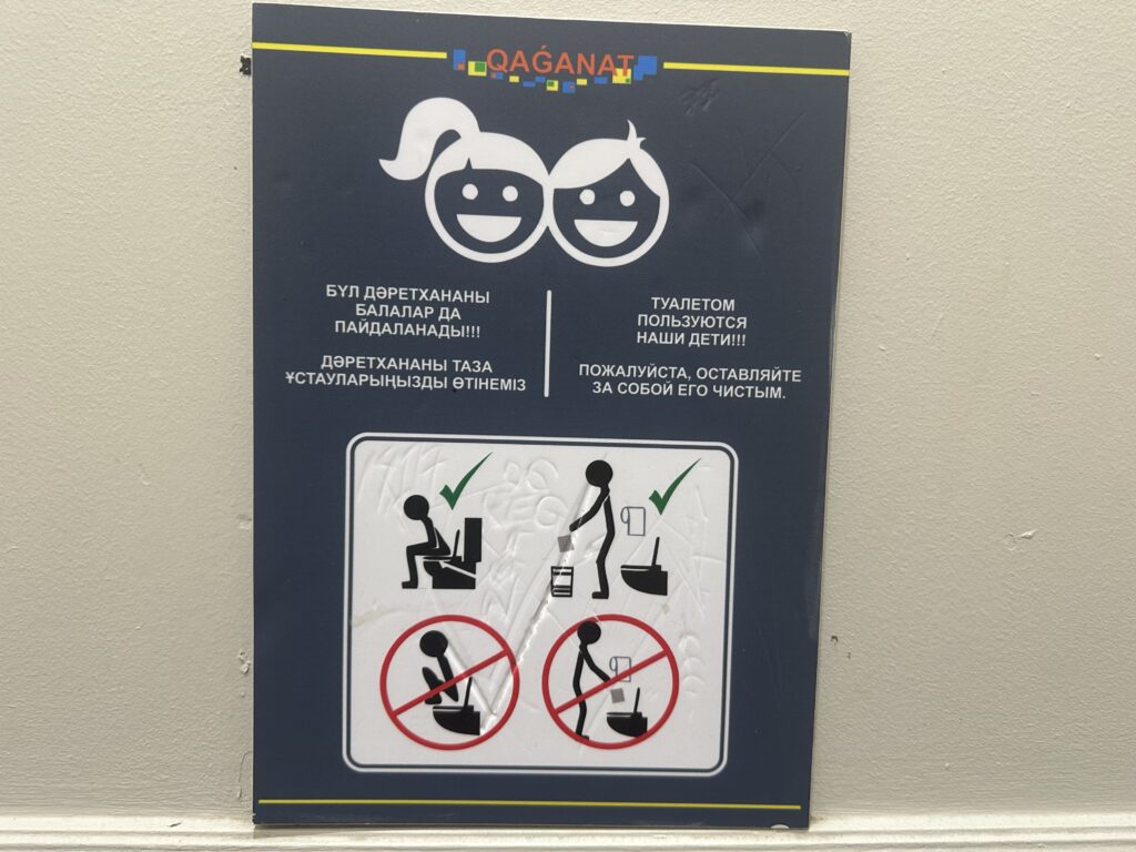

I have a few signs that are hilarious. One of my favourites is the two side by side pictures of a person to illustrate the good and bad choices one could make on a conventional sit down toilette. Stick people are used to illustrate. Beside the word “yes” he is sitting; beside the “no” he is leaning forward and blasting, a definite no no! Also when using a Western toilet they want to let you know that standing on it is not correct.

The old adage “never pass an opportunity” sure was true. Our guides were careful in advising us of the possibilities, or lack thereof.
One other characteristic: the guardians of the facilities and takers of the toilet tolls are usually female, and they take their responsibilities seriously. You cannot get access unless money is produced (and usually in such small denominations that you often don’t have it). They all have golden smiles; gold teeth are a common orthodontic feature (of both the women and men).
12. A very old chachvan – my big “mask” purchase
First, two things to preface: I collect masks from countries I have visited. (This is not the place for why, and what they are and represent – but I do have over 200 and they really are fascinating.) The second point is that the Stans don’t have cultures that use masks in religious, ceremonial or artistic ways.
But, yes of course, they do. Or they did – for in the old days women covered their face with shawls, i.e. masks of some sort. It was common practice for women in Central Asia. Chachvans were worn beneath capacious veiling garments or cloaks called paranjas. Dating from the end of the nineteenth century and the beginning of the twentieth century, the chachvan and paranja were mandatory street wear (they were never worn inside) for all urban Uzbek and Tajik women, from girls of a marriageable age to elderly matriarchs.
This “veil” (or paranja) was similar in basic style and function to other regional styles such as the Afghan chadari. (It was also known as “burqa” in Arabic). As I said, the actual part that covered the face, known as the chachvan, is heavy in weight and made from horsehair. It was especially prevalent among urban Uzbeks and Tajiks.
But the Soviet Union in their Bolshevik revolutionary enthusiasm banned them. In March 1927 The Communist Party of the Soviet Union initiated a series of policies and actions (called the hujum) to remove all manifestations of gender inequality, especially the systems of female veiling and seclusion practices in Central Asia. The Russians aggressively imposed the ban, often tearing the “veil” off from a female’s face. Women were encouraged to burn their chachvans and paranjas. By 1959, they had all but disappeared.
So I decided to try and buy one. It dawned on me that there might be one of those old chachvans lingering in a closet in somebody’s home. When we were in the city of Bukhara, Uzbekistan I went to a market place and asked the proprietor of a stall that sold all manner of clothing whether he knew how to obtain one. He inquired about and came back to me with the possibility that he could obtain one. He asked me to return in about two hours and would show me what he tracked down.
When I returned he presented it to me; you could tell it was authentic, and quite old. The predominantly dark brown horsehair face veil is rectangular in shape and of looped construction. The veil is bound across the top and down the two long sides with a wide, matching brown cotton strip. Across the fourth side (the lower edge which hangs down to the chest when the veil is worn), light coloured horsehair has been incorporated in the looping to provide a decorative edging. A button is sewn to the top left hand corner and a corresponding loop at top right for fastening the veil into a circle for placing on the head.
After some price negotiation, I purchased it. The chachvan is heavy, made from horsehair and is over 100 years old, a relic from a strange era.
This is Penny reluctantly modelling my purchase.

13. The Borat echo
I couldn’t get the black comedy movie starring Sacha Baron Cohen, out of my head. Borat! Cultural Learnings of America for Make Benefit Glorious Nation of Kazakhstan was quite a controversial film when it was released in 2006. Borat was offensive in the funniest but cringe-inducing way.
Borat, the fictional Kazakh journalist, travels through the US supposedly to make a documentary which features real-life interactions with Americans. He travels with two companions, his producer, Azamat Bagatov, and a pet chicken. Two scenes of many that linger are Borat’s horribly memorable and disgusting nude brawl with Azamat, plus the proud introduction of his sister as the “number four prostitute in all of Kazakhstan”.

At first the movie was denounced by the Kazakh government and was banned in almost all Arab countries. But I was told they are now more relaxed about it. The Kazakh ambassador to the United Kingdom wrote that the film had “placed Kazakhstan on the map.” The Kazakh Foreign Minister attributed a rise in tourism to his country due to Borat.
Wrap-up
That’s it for the vignettes.
The attachments (see: https://powellponderings.com/attachments-to-blog-journey-around-the-5-stans-in-central-asia/) will provide a more complete description of the very diverse cities we explored. A brief few words on history will be provided, although complexities will be avoided. Religion, food and drink, plus language will be addressed. I finish with a summary of our itinerary.
Read it all
Thanks for informing us on something we will never see
Fantastic journey for sure
Your ability to remember so many details is inspiring
Sure makes you appreciate our beautiful country
Thanks Ken
Best blog so far . Well done . You brought your journey to life
Kindest regards
Jim
Good work Ken.
You really travel the world.
Scott
Remarkably informative account of your amazing trip.
Great easy read and informative to the point.
As you know Mary and I have travelled the world but nothing like this. Close though.
My sincere complements. Nick
Ken, Thanks for sharing your photos & details about this amazing trip. However I agree with Penny a bit rough & dangerous for my taste. Your research about the history of the Kans was masterful & most interesting.
Fascinating, Ken. Thank you for your vivid descriptions of these countries I will probably never see or experience.
Well done Ken. You continue to amaze and enlighten me and I will look forward to your next blog.
Outstanding rendition of a fantastic trip
CONGRATS. Big time. Love to hear more at the lake 👍👍
Memories Memories
Remember Nancy and I in 1969 found ourselves in Kabul so we journeyed ( for a visit 😎) to Uzbekistan , directly north Of Afghanistan !!! Wow never forget ,
flat like Saskatchewan, cotton cotton and a weaving plant that seem to go for miles , storks on chimneys 👌
Am jealous CONGRATS big time
Your admirer
Phil MacD
Thanks for sharing Ken. A wonderful read, brought back memories of a great trip. Loved travelling with you.
Lynne and Ian.
Kenny: Just a wonderful Blog .Taking us into an unknown world in such a first hand personal way-a very good job Ken !
I am proud of you , your accomplishments and legacy-now including family -even better!
Best John Wildman
Powerful peripatetic ponderings!
thanks for a fascination look at the Stans
Great blog, Ken. The Stans were never in my bucket list, and now that I know as much as I want to know about them from this wonderful blog, they are never going to creep into the bucket. Thank you.